The view from the Management’s seat

How we plan the route and use the GPS

Home Page       The Route       Week 1       Week 2       Week 3       Week 4       Week 5       Week 6       Week 7       Week 8      

Bike and Gear       Navigation and the GPS       Stoker’s leg      

Even the cheapest GPSs starting at around £100 will tell you exactly where you are using a grid reference or latitude and longitude. We use the Garmin GPS Map76S. It’s a bit long in the tooth in technological terms but it serves us well and is a very robust and sophisticated machine.

Touring cyclists seem to have been remarkably slow to latch onto Satellite Global Positioning (GPS) Technology. This is surprising because GPS can not only tell you where you are on the map but it also provides more information to the rider than the average cycle computer.

So this is how we plan our tours. First we need an idea of where we want to go on a tour and how long we can spend away. This can be the most difficult part. Having made this important decision we buy a paper map at about 300,000 scale and a copy of the Rough Guide for the country. From these we plan a rough route with the places we would like to visit.

The next step is to use the ancient Autoroute package which came with our PC. We put into Autoroute our overnight stops, estimated speed and tell it we can’t go on motorways and don’t much like main roads. It then plans our route in a few seconds. In fact it does everything that the CTC did for Ken’s first big tour in 1972 and provides full cycling directions.

The Stoker’s tiny GPS

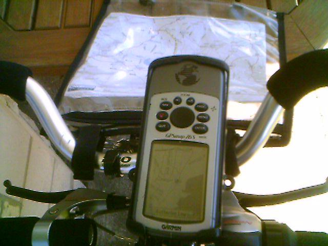
Then we use Garmin Mapsource software which costs about £120 and has detailed road maps of all of the UK and most of Europe, but unfortunately not Ireland. The level of detail does vary but for example in the UK its road network is far more detailed than a 50,000 OS map. The downside, and it can be important, is that it does not show contours or off road routes.

When we are happy with our basic route we put the stops into Mapsource as waypoints and build up the route. We then carefully work out how we will cycle between each waypoint. When we are happy with this we print out the maps showing our route at a scale of about 50,000. At the speed we cycle this is easy to read but does not require constant turning of pages on the road.

On the road Ken has the GPS with the map loaded mounted on the handlebars and the printed map in an old fashioned map case. That way he can get the detailed picture on the GPS screen and the bigger picture from the paper map. Not only does he know within a hundred metres if he takes a wrong turning but he has more information about the ride at a press of a button than his brain can cope with.

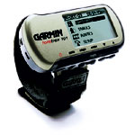
Following the rebuild of the tandem this year we decided that we no longer wanted the old fashioned inconvenience of cycle computers. But the Stoker wants trip information. She decided to try the Garmin Foretrex GPS and this also works well though it does need a clear view of the sky. It cannot load maps but is very small and not too expensive.

Home Page       The Route       Week 1       Week 2       Week 3       Week 4       Week 5       Week 6       Week 7       Week 8      

Bike and Gear       Navigation and the GPS       Stoker's leg      

This site is created and maintained by Anne Neale and Ken Reed.