Usually we use Garmin Mapsource software which costs about Ł120 and has detailed road maps of all the UK and most of Europe, but unfortunately not Ireland or the Canaries. The level of detail does vary but, for example in the UK, its road network is far more detailed than a 50,000 OS map. The downside, and it can be important, is that it does not show contours or off road routes. For the Canaries we need to use the base map which, while suitable for US tourists, only shows major towns and roads.
When we are happy with our basic route we put it into the GPS by drawing it on Google Earth. We do this using http://www.gmap-pedometer.com/ (see links) and saving the route as a .gpx file. We then carefully work out how we will cycle each moving on day and where we will go. We then highlight these places on the 50,000 military maps.
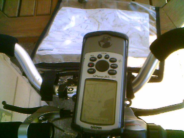
On the road Ken has the GPS with the route loaded mounted on the handlebars and the printed map in an old fashioned map case. That way he can get the detailed picture on the GPS screen and the bigger picture from the paper map. Not only does he know within a hundred metres if he takes a wrong turning but he has more information about the ride at a press of a button than his brain can cope with.
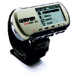
Following the rebuild of the tandem last year we decided that we no longer wanted the old fashioned inconvenience of cycle computers. But the Stoker wants trip information. She has her faithful Smarty Pants, a Garmin Foretrex GPS with over 5,000 miles on the clock, and this also works well. It does need a clear view of the sky and it cannot load maps even if they existed. But it is very small and not too expensive and does have track back when the Management gets lost.
Home Page
The Route
Week 1
Week 2
Week 3
Week 4
Week 5
Week 6
Week 7
Week 8
Week 9
Week 10
Tandem by Air
Bike and Gear
Navigation and the GPS
Stoker's leg
Links+Downloads
This site is created and maintained by Anne Neale and Ken Reed.