Days 17 and 18 24th and 25th November Morro Jable, Fuerteventura
We are staying in an apartment hotel in this large seaside resort, booked on the internet with a Spanish booking agency. Even though beds abound in these large resorts it is often difficult to find somewhere by just turning up as the package holiday companies block book for the whole season.
Morro Jable is on the end of a very long white sandy beach often rated as the best in the Canaries. It is also situated at the start of a long narrow panhandle of the island with a steep spine of mountains rising to over 800 metres.
We slept well, tired after yesterday's ride, and set out to explore the town on foot. This is the best way because the over built environment stops most easy exploration by bike. The whole place is populated by Germans. We were addressed in German wherever we went and most people we spoke to had no English. However European we are it does tend to make us think of 'Hello Hello' and 'Dad's Army' jokes.
It has to be said that this is a rather nicer resort if you like that kind of thing than the English resort of Corralejo we stayed at in the north of the island. There is some high rise but nothing like the awful mess in the north. We suppose you get what you pay for and the Germans pay more.
We found a motor bike shop selling bike bits in the old part of the town. They did not have quite the right sized chainset for the tandem but at least they had something that would have done the job. As the broken one seems to work most of the time we decided not to change it.
Walking back along the wide and busy sea front exhibitionism was the order of the day. We were confronted by many elderly Germans' willies often well past their best and sometimes in grotesque poses. There were also the very occasional younger men who from the way they behaved could well be rent boys. The women were more discreet.
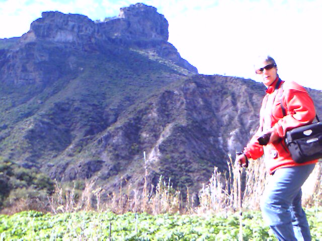
Having slept well, despite the noise from the local clubs, we decided to explore the Peninsula de Jandia. This involves a 50km ride mainly on unmade roads. It may not be as demanding as the Dorset Dirt but is about the same distance and is a long way for us off road.
It was cloudy when we left with a strong headwind blowing. As we came to the top of the first rise we were amazed to see a rainbow. Bearing in mind we have not put on waterproofs in nearly three weeks it was a great bonus. The clouds persisted but it did not actually rain.
The track followed the line of the mountains with many twists and turns. We were not as alone as we would have liked to have been. On an island with so few tourist attractions many could not resist hiring a vehicle and driving 50 sick making kms on an unmade road. The slight damp in the air did tend to lay the dust on the road.
Most of the time we only had the company of the wild goats and each other. Off the road it does not look like good mountain biking country but the walking looks excellent. There are many valleys to explore and the steep faces on the northern side of the mountains should give great views as well as a suicide opportunity.
As we approached the far west of the island we were in a barren flat land battered by the open Atlantic. Few places rival Chisel and Portland Bill on a windy day and this is one of them. It also has the advantage that it is 20 degrees warmer this time of the year.
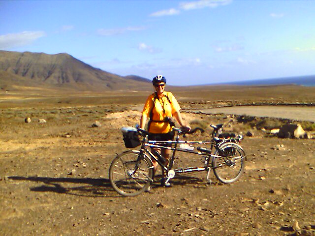
The stoker was delighted when the tarmac promised on the map near the lighthouse appeared. Between naked fear on the descents and excessive pedalling on the climbs she had been cosseted by her leather saddle and sprung seat post. Even so the smoothness was very welcome. The tarmac runs north south along the beach and smacks of the military. Perhaps it was built to watch the German U boats who, like their successors, hid here during the war.
We enjoyed the waves and ate our picnic lunch brewing up in the shelter of the lighthouse buildings. We were then surprised to see a couple, German cyclists in their 50's, arrive on hired mountain bikes. They did not look particularly fit and it was a hard ride.
There is a small settlement here, rather like there is on Portland Bill. Here the similarity ends and we were grateful for regulation in the UK. The built environment consisted of a village of crumbling buildings built in the Spanish blockie vernacular. Surrounding it were several lines of rusting campervans and caravans. It looked like the worst kind of new age community. And we didn't want to ask where the waste and sewage went. There was, however, one huge wind turbine which appeared to be bust.
Having hung around for quite a while, and the sun having come out, we began to think about going back. It was a retrace but the views were completely different on the return trip. Here, as in the rest of the civilised world, the four wheel drives are a pain. Those in little hired cars drove along slowly avoiding the bumps. Many of the four wheel drives roared along tearing up the track and causing huge clouds of dust. The management confused them by insisting on passing to windward, whichever side of the track that was. Apparently these gas guzzling monsters not only damage the track but also spoil the dunes and mountains by going where they shouldn't. There has to be a case for a ban.
About half way back we saw the German mountain bike couple in the distance. It is unusual for us to overtake any but pedestrians so we knew that they were having a hard time. We felt for them but there was nothing to be done. The management thought it was somehow unBritish to go steaming by and hung back for a while. In the end we had to overtake. We tried to give them our best wishes but they looked well beyond that. They were probably deep in the realms of matrimonial disharmony.
Day 19 26th November Morro Jable, Fuerteventura to Las Palmas de Gran Canaria
At the start of this moving on day the sky was completely clear. From the vantage point of our 9th floor balcony the bright blue sea contrasted with the white sandy beach and crashing waves. There must have been a storm in the Atlantic and the red flags were up and swimming too dangerous.
Our plan today before we left was to reach a view point on the spine of the island. We cycled past the smart but intrusive German hotels and turned right into an urbanisation where the Spanish working classes were enjoying their Sunday off. Here the made road ended and we were onto dirt tracks.
It was a steady climb past shanty houses made of boxwood, old vehicles and the like, each on its own smallholding. There was even a saloon, wild west style with several dusty trucks parked outside. As we went on upwards the cautious stoker began to fear for her safety as the track became rougher and looser. It did not help being accompanied by the constant loud barking of the chained guard dogs.
Eventually we could ride no further and, locking the tandem to a tree, took to our feet. Even further up the management went on ahead as an advance party to try to gain the summit. He failed, declaring that although he could see the way the steep drop from the slidy path made it too dangerous. Defeated we returned to the digs for lunch and siesta.
By 6pm we were on the car ferry to Las Palmas de Gran Canaria. It was nice to be among Spanish speakers again and the occasional traveller and away from the package holiday beach lizards. The boat docked in a different part of the huge port from where we had left. It confused the management a little but he soon found the way back to the commercial hotel next door to the main fruit and veg market.
 |
This is as far west as you can get on Fuerteventura after travelling 25km on dirt roads, and it is rough |
Day 20 27th November Las Palmas to La Culata, Gran Canaria
Today the management failed in his managing responsibilities in every respect with the possible exception of stoker management. His basic plan, though laudable, was wildly optimistic. It was badly researched and he had no fall back position. He failed to implement it well and had it been a business plan he admits he deserved to be sacked. Let this be a lesson to you if you are ever rash enough to take on a management role.
It all started normally enough with supplies being obtained from the market and breakfast on our balcony. We got away sharply before 10am when any sensible person would have left by nine. We found the north promenade and rode along it as planned. Lulled by the crashing waves and the friendly people he went to the end when he should have turned off 300 metres earlier and crossed under the coastal road.
The Spanish military maps we have for this trip are very accurate and extremely detailed. They sometimes fail to keep up with the frantic speed of Spanish road builders, but not in this case. He was not even aware that he had missed his turning and continued along the spectacular coast for about 4km. Confronted with an unexpected seaside village his error became all too clear.
Poring over the map the only way now involved a major climb up a steeply zig zagging road. We did it but not without wasting a lot of energy that we were likely to need later. At the top we descended to a roundabout and correctly turned right.
Soon after the turn the map and the GPS indicated that we turn left. What did the management do but go straight on, not only that but through a tunnel, pleased that the tandem's automatic light worked. A tunnel is a major feature marked on the map but the management ignored it. He did, however, have the opportunity to see his light work again, this time on the climb back through it.
Finally back on the right track the management managed to be defeated by a silly village one way system. To get back on the right road we descended into a deep valley and up the other side. Even the long suffering stoker refused to ride down it was so steep and even the management could not ride up.
After all this needless effort he had his first piece of good luck. He was not actually on the right road but as it transpired a much better road. After a few kms of steady climbing he realised his mistake but it was far too late to turn back. Even bad managers have good luck sometimes.
The road we were on was a not too busy A road and as such carefully graded. It is the best kind of tandeming road and we made good progress gaining height steadily. Most of Gran Canaria's population lives in the north and we were by no means out in the wilds. The valley we travelled up was very pleasantly green, particularly after the desert scenery of Fuerteventura.
Here at least the management did something right. Seeing a pleasant cafť he stopped for proper lunch. Meals here are served quickly. We did not rush but even so were on the road again properly refreshed within an hour.
Then the management made his final mistake of the day. Seeing a more direct side road on the map he went for it. He learned the hard way that when a main road goes round lots of bends in the mountains it is smoothing the gradients. We were again reduced to walking.
The remainder of the day was a dismal affair although the scenery was wonderful. As we went higher we passed through several different types of vegetation including beech trees shedding their leaves and then pine trees. We were now on more minor roads with hardly any traffic.
The management now spent his time poking the GPS to get our altitude. He could not believe the height we were attaining of 1300m then 1400m and finally over 1500m. By now we were both very tired and barely travelling at walking pace. Well before we reached the top of the climb the sudden darkness of this latitude made life even more miserable.
Fortunately for us our salvation was in the German technology of our lights. Not only did the strong dynamo driven beam make it easy to read road signs but the standlight made it possible to read the map. Even so the final part of the climb was a sad business.
At the top we now knew that we had six or seven km to go but not that they were all down hill. Now with our jackets on and cold from the previous perspiring we were descending the hairpin bends on the mountain road as quickly as we could. It is not all that safe at night because oncoming vehicles used to the mountains guage the bends on the basis of the lights they can see above then. Our bright light was still not as strong as car lights. A near miss with a bus made us extra cautious.
With relief the stoker spotted the sign to our lovely cosy casa rural. Alex, the owner's grandson, was there to meet us and show us in. It was now 7.30pm and we had been on the road since before 10am. Alex had been expecting us since 5pm. The computer trip figure is classified but the maximum height gained was 1505m, we were now at 1285m and we started at sea level.
It is the management's job to cook. He was very contrite and did his best. At first the stoker was too exhausted to eat but coaxed by nice smells and red wine she managed her share. It is hard to sack a management who can cook and of whom there is no obvious replacement. Knowing this and having our blame free culture there was no retribution but only relief at having arrived.
Day 21 28th November at La Culata Gran Canaria
The management remembers cycling with his children to Ironbridge. We arrived in the dark in the rain. Thoroughly miserable we checked into a B&B. In the morning we woke in a lovely place and the sun was shining.
Our casa rural is a traditional canarian house, single story and built into the mountainside. The thick stone walls keep out the heat and the cold and it is heavily shuttered. When the management awoke he threw open the shutters. Just as he did at Ironbridge.
The view was spectacular. We were perched high in the mountains above the village of Tejeda. To our left and in the foreground are huge peaks with rocky towers atop. In the far background is the peak of Mount Teidi on the island of Tenerife. We expect to be there in about six weeks.
Fully breakfasted on leftovers and the nice sweet things the owner had left us we set off for a walk into Tejeda. Alex had assured us that twenty minutes was all it would take. An hour and a half later we arrived, did our shopping and got a bus half way back. The village was nice but scrambling down the mountainside did nothing to improve the stoker's still tired legs.
Late in the afternoon we were very sorry to miss Dave Crowther and family who had driven all the way up from the coast to see us. The bottled water they kindly left was very welcome, but not much compensation to them for a long drive. They also missed the almond cakes for which Tejeda is justifiably famous hereabouts.
Home Page
The Route
Week 1
Week 2
Week 3
Week 4
Week 5
Week 6
Week 7
Week 8
Week 9
Week 10
Tandem by Air
Bike and Gear
Navigation and the GPS
Stoker's leg
Links+Downloads
This site is created and maintained by Anne Neale and Ken Reed.