The files are in .zip format. They need to be unzipped and saved to a directory of your choice. You can then load them into the appropriate application and GPS.
The Blog
Raymonds Hill to Newton Abbot
Saturday 23rd April 2011
Leaving the highly recommended B&B at Raymonds Hill we turned left onto a tiny lane carrying two rather worn signs, No Through Road and Sustrans Route 52. After a short climb this dumped us at a crossing of the main coast road. We crossed with difficulty, it would be easy for the Highways Agency to put in a small refuge here for pedestrians and cyclists to replace existing chevrons. It would be even easier for Sustrans to put up a sign.
From here we continued on one of those magnificent ridge roads. Without any significant hills we had lovely views on the bright sunny morning over green fields and woodland.
At our second main road crossing, much easier than the first, we continued onto another tiny country lane marked with a No Through Road sign. This soon became a bridleway sunk deep between two hedgerows. It was too rough for us to ride though it ought to be possible on a robust tourer and easy for mountain bikes.
After only about 400 metres of walking we came to a large gatehouse for Rousdon Estate, formerly All Hallows College. We passed under its arch and were again on tarmac roads. The college is a complete community with its own church. We dont carry our Pevsner with us but the beautiful buildings seem to date from the 19th century but are in an ornate gothic style.
Leaving the college grounds we were soon descending very steeply indeed on a very bumpy lane towards Seaton. Anne experienced here, as she did several times later in the day, great difficulty holding her Brompton on the brakes. Inexcusably Brompton have found a mass of totally unjustified excuses over the years for not using V Brakes. Kens bike, adapted by Stephen Parry, had no problems stopping.
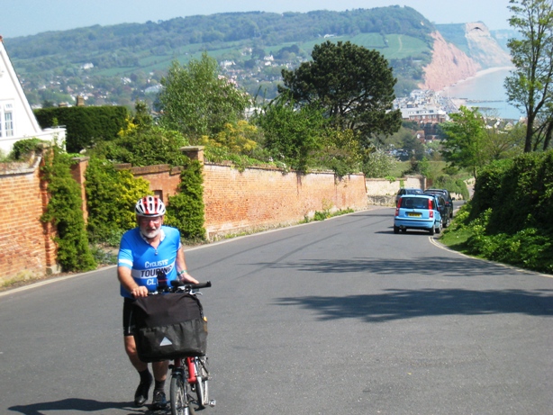
Sidmouth Hill
The road into Seaton was rather busy and the town itself is cycle unfriendly. There is no cycling allowed on the promenade and several one way streets without contraflow cycle lanes prevented legal cycling along the seafront. We stopped here for a second breakfast. Amusingly on a roundabout near the café someone into community art had used some old bicycles. Perhaps the owners who donated them had found riding them in the Seaton traffic system unrewarding.
From here we continued along the coast on lanes with so many steep climbs and equally steep descents that we lost count. The route itself was lovely, particularly through Branscombe and along the lanes to Sidmouth. There was a good deal of traffic, mainly visitors, many uncertain of the width of their cars and nervous of the stone banks. We wondered what would pose anyone to be voluntarily confined to a tin box on such a lovely day, especially when fuel prices are so high. It seemed particularly cruel when children were involved.
After the massive climb out of Sidmouth unsurprisingly Nannys battery decided to expire. We had a pleasant descent into the village of Otterton and stopped at the village pub for a late lunch, putting the battery on charge for an hour. It was nice to see that the pub was busy, mainly with walkers, all armed with at least one stick, and some other cyclists.
From here the route to Exmouth and the Starcross ferry is both easy and very lovely. It follows the east side of the River Otter on a traffic free lane on a bank high above the river. It skirts Budleigh Salterton before following a well surfaced disused railway track to Exmouth.
As we neared the ferry signage became something of an issue. Also someone, no doubt a well meaning but misguided functionary, had decided to paint a white line down the middle of the cycle route. These lines of course immediately provoke confrontation with walkers and cyclists asserting territorial rights and dogs ignoring them completely.
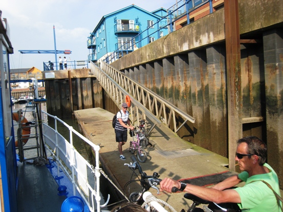
Exmouth to Starcross Ferry
We missed the ferry by a few minutes and had to wait an hour for the next. The 16.40 ferry is the last at this time of the year and was very full with at least a dozen bicycles. It was a very pleasant 20 minute crossing in the sunshine.
On the Starcross side we had to carry the bikes up steep wooden steps to the jetty. We then gained Starcross rail station. We decided to end our cycling day and take the 30 minute train journey to Newton Abbot. Had we been going on we would have had another carry over the pedestrian rail bridge. All of this is sadly of course impossible for wheelchair users.
The section of our cycle route between Starcross and Newton Abbot went down the coast to Dawlish and from there into country lanes involving a climb to about 200 metres. There are no designated cycle routes that we know of in this area and the main road is very busy. By taking the train we cut 12 miles (18km) and a very big hill from our planned route.
The trains that stop at Starcross and Newton Abbot all carry bikes without reservation. We did not need to fold the Bromptons even though there were already three bikes onboard. In our experience most of the guards are not that bothered about how many bikes are on board and it is best to be nice to them if you plan to break train company rules.
We had prebooked a pleasant B&B in Newton Abbott and braved the usual Saturday night revellers or, as we used to say, drunks to get a meal in a pleasant pizza café.