It was yet another lovely day and we allowed ourselves the luxury of leaving late. It was gone 10.30 as we pedalled along the main road out of town. Minor routes do exist here but are best suited to climbers. We turned right off the main road after about 3km. It was busy on this stretch of main road but doable for us.
We were soon plunged into a maze of lovely country lanes, all the verges were covered in spring flowers and the wooded areas carpeted with bluebells.
Fortunately for us this area does not appeal to car driving tourists out for the day. In stark contrast to yesterday we met few vehicles and for much of the time the only sound was bird song.
At first the cycling seemed to be easier than yesterday but then almost anything is easier than the hills into and out of Sidmouth. We also seemed to be working well together today with Anne gaining on the climbs and Ken catching her on the descents.
As we descended into the Dart Valley towards Staverton we heard in the distance the unmistakable whistle of a steam train. A quick glance at the map confirmed that we were running parallel to a railway line. A little further along the road we came to Staverton Station just in time to see the last carriage of a steam train disappearing into the distance.
Following the usual convention the level crossing was near to the tiny signal box. The friendly signalman volunteered that the up train was due soon.
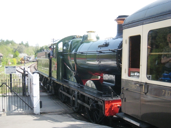 |
Staverton Station
|
A few moments later the signalman closed the manually operated level crossing gates to the road and the nearby signal arm dropped down. In the distance we could here the rat-a-tat-tat sound of the coming train and as it approached the hiss of steam and the whistle.
The train stopped briefly in the station with the engine above and right beside us. The fireman was working hard stoking the boiler as it pulled out on its way to Totnes.
We continued our ride crossing the Dart at the ancient bridge near the rail station. We then had a long almost never ending climb out of the Dart valley. We finally crossed the main Plymouth road and entered Dartmoor National Park.
The first village we came to in the Park was South Brent and we soon settled down for a nice lunch at the Royal Oak. As on previous days we were able to put Nannys battery on charge for an hour increasing the range by about 12km. By the time we left it was almost 15.00.
At another brief refreshment stop 12km down the road we realised that a bike lock and one shoe were missing from the bag. This was a mystery which we never solved despite phoning the various places we had been.
At Ivybridge, which sadly appears rather down at heel, we made the mistake of following Sustrans Route 2. It took us a good deal out of the way on a badly signed rubbish route some of which was beside a roaring main road. As we entered the outskirts of Plymouth Sustrans Route 2 simply disappeared and maybe that was for the best.
Ken of course loves route planning. As usual he had done his homework and downloaded onto the GPS. We proceeded via a network of small roads to the Plym Valley Route 27 on the signs and the West Devon Way on the Ordnance Survey map .
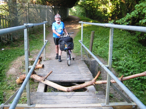 |
Cycle Bridge - Plymouth
|
All was well and good until we came to a Road Closed sign. As no one had bothered to post any diversions we had little choice but to follow it. The unsavoury path eventually came to a wooden bridge over a stream. Some of the transverse planks had broken leaving a hole in the bridge. It would have taken Ken a couple of hours to cut and put in replacements. It probably took the council workers more time than this to put up the barriers needed to block the route.
Local people rightly took matters into their own hands, throwing the expensive plastic barriers into the stream and bridging the gap in a makeshift way with a log. Good for them.
We got the Bromptons across the bridge and followed the path down beside the estuary. It all looked as if it could do with a bit of maintenance but the route was excellent. However the end of it is rather bizarre. It passes beside a permanent travellers camp nestling below what looks like a restored ex-rubbish tip. We feared for the expected out of control dogs. None came, and the essential tethered ponies looked very sleek.
The route crossed the Laira Bridge over the estuary and there it ended. The National Cycle Route was crossed through and the alternative blocked by extensive road works. We followed the cycle route, almost losing each other in the process, to its bitter end. It would appear that the route ended because housing was built over it.
We found minor roads from here into the city centre. We had a meal at the Bella Italia, an overpriced joint which would not allow us to charge the battery. It was, however, just about the last eating house on our route to the ferry.
Boarding the Brittany ferry here is rather good for cyclists. There is a waiting room near the head of the queue with a TV, comfortable seats, and chocky bar and drinks machines. We were even told when we could board.
Travelling on this ferry was a rather bizarre but good experience. We boarded the ship without seeing anything except the car deck. We took a lift to our cabin and opened the door with our electronic boarding card. We went to sleep and abracadabra emerged from the car deck into Roscoff without a glimpse of the sea or exploring the ship.