The route is in blue:
Weymouth to Sutton Poyntz
The route to Sutton Poyntz to the east of Weymouth is one of our favourites. It is a pleasant ride on quiet roads and paths. It serves the residential areas of Preston and Sutton Poyntz as well as the holiday parks to the east of Weymouth. It is also not very hilly.
It is suitable for all types of rider including children. It is also suitable for most types of bike though there are some unmade sections which would be uncomfortable on a light weight road bike. Those on trikes, trailers and heavily laden tandems will need to take a short diversion (see below) but otherwise should also be able to enjoy this route.
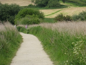 |
The cycle path across Lodmoor Country Park |
You start from the Swannery car park going north on the cycle track on the wide pavement beside Radipole Park Drive. You soon turn right to cross the railway via the excellent Alexanda cycle bridge.
You soon cross the busy Dorchester Road and you can use the pelican crossing near to Tesco if you find this road intimidating. After another short stretch on minor roads, passing Weymouth College, you travel on a cycle track through the Lodmoor park.
After some further quiet residential roads you will reach a footpath near to Chalbury Corner. It is about 150 yards long with barriers and you will need to walk here. If your bike will not fit continue on Wyke Oliver Road, turn left at the end onto the busy Preston Road and left at Charlbury Corner before rejoining the route at Combe Valley Road.
There is another short stretch of unmade road at Puddledock Lane. It is not to bad but the puddles made by motor vehicles can be deep in bad weather.
Sutton Poyntz is a pretty village and the water works is well worth a visit. There is a pub but it is rather upmarket as are some of the local residents. It is not possible to get further east from Weymouth on the coast with out going seriously off road or braving the traffic on the A363.
Downloads for this route
The following files are in .zip format. They need to be unzipped and saved to a directory of your choice. You can then load them into the appropriate application.
This route in Google Earth format to open in the Google Earth application
This route in Garmin format version 2 for uploading to your GPS
This route in Memory-Map format, waypoints only, for uploading to computer's software
This route in universal format for uploading to many applications
Copyright © 2009 Ken Reed and Anne Neale
This is the the route in .kml format
This is the the route in .gdb format
This is the the route in .mxf format
This is the the route in .gpx format